


DJI Enterprise
Zenmuse L3 LiDAR
Zenmuse L3 LiDAR
1535 nm Long-Range LiDAR Payload with Dual 100 MP RGB Cameras
Next-generation LiDAR meets enterprise reliability. The DJI Zenmuse L3 integrates a 1535 nm long-range LiDAR, dual 4/3 CMOS 100 MP cameras, and a precision RTK POS system into a compact, stabilized payload for the DJI Matrice 400. Designed for large-area mapping, corridor inspection, and industrial survey missions, the L3 delivers centimeter-level accuracy from flight altitudes up to 300 m AGL — even on low-reflectivity surfaces.
Key Features
- Extended Range & Accuracy: Capture dense point clouds up to 950 m @ 10 % reflectivity and 2000 m @ 80 %, with vertical accuracy 3 cm (120 m) / 5 cm (300 m) RMSE.
- High-Precision Dual RGB Cameras: Two 100 MP 4/3 CMOS sensors provide 107° combined horizontal FOV for detailed colorization, orthophotos, and 3D meshes.
- Versatile LiDAR Modes: Linear, Star-Shaped, and Non-Repetitive scanning (80° × 80° max FOV) adapt to terrain and canopy conditions.
- Enterprise Ecosystem Integration: Collect in DJI Pilot 2, process in DJI Terra, refine in DJI Modify, and share via FlightHub 2 for end-to-end workflows.
- Rugged and Reliable: IP54 rating, operational from –20 °C to +50 °C, compact 1.6 kg design optimized for Matrice 400 missions.
Applications
- Survey & Mapping: Large-area topography capture ( > 100 km² per day ) with centimeter-grade accuracy.
- Forestry & Vegetation Analysis: Multi-return LiDAR penetrates dense canopies for terrain and biomass data.
- Mining & Quarry Operations: Safely map steep pits and stockpiles from distance using long-range 1535 nm laser energy.
- Infrastructure Inspection: Detect fine structures and wires with wire-detection ranges up to 300 m (21.6 mm steel core wire).
- Public Safety & Emergency Response: Rapid damage assessment and search scenarios with geo-referenced point clouds and orthomosaics.
Technical Specifications
System Specifications
- Product Name: Zenmuse L3
- Weight: 1.60 kg (without gimbal connector) + 145 g connector
- Dimensions: 192 × 162 × 202 mm (L×W×H)
- Power Consumption: 64 W (typical) / 100 W (max)
- Supported Aircraft: DJI Matrice 400 (via Zenmuse L3 Single Gimbal Connector)
- Ingress Protection: IP54
- Operating Temperature: –20 °C to +50 °C (–4 °F to 122 °F)
- Storage Temperature: –40 °C to +70 °C (–40 °F to 158 °F)
Point Cloud & Accuracy
-
Point Cloud System Accuracy:
• @ 120 m: Vertical 3 cm (RMSE) | Horizontal 4 cm (RMSE)
• @ 300 m: Vertical 5 cm (RMSE) | Horizontal 7.5 cm (RMSE) - Point Cloud Thickness: 1.2 cm (120 m) | 2 cm (300 m) @ 1σ
LiDAR Module
- Laser Wavelength: 1535 nm (Class 1 Laser)
- Beam Divergence: 0.25 mrad (1/e²)
- Spot Size: Φ 41 mm @ 120 m / Φ 86 mm @ 300 m
-
Detection Range:
700 m @ 10 % (350 kHz) • 950 m @ 10 % (100 kHz) • 2000 m @ 80 % (100 kHz) - Wire Detection Range: 21.6 mm steel core wire – 300 m @ 100 klx / 350 kHz; 18.4 mm PVC wire – 100 m @ 100 klx / 350 kHz
- Ranging Accuracy: ± 10 mm (absolute) | < 5 mm repeatability (1σ)
- Minimum Detection Distance: 10 m
- Laser Pulse Frequencies: 100 / 350 / 1000 / 2000 kHz
- Number of Returns: 4, 8, 16 (100 kHz & 350 kHz); 4, 8 (1000 kHz); 4 (2000 kHz)
- Scanning Modes: Linear (80°×3°), Star-Shaped (80°×80°), Non-Repetitive (80°×80°)
RGB Mapping Cameras
- Sensor: 4/3 CMOS × 2 (dual cameras)
- Lens: 28 mm equiv, f/2.0–f/11, FOV 73.3° (diag) / 62° (h) / 41.2° (v)
- Combined FOV (Dual): 107° horizontal
- Resolution: 100 MP (12288×8192) | 25 MP (6144×4096)
- Photo Interval: 1 s (JPEG 100 MP) | 1.2 s (RAW)
- Video: 4K 30 fps / FHD 30 fps (HEVC/H.265)
Position & Orientation System (POS)
- GNSS Update Rate: 5 Hz
- POS Update Rate: 200 Hz
- Attitude Error: Yaw 0.02° | Pitch/Roll 0.01° (1σ)
- Position Accuracy (RTK Fix): Horizontal 1.0 cm + 1 ppm | Vertical 1.5 cm + 1 ppm
Gimbal & Mounting
- Degrees of Freedom: 3-axis (pitch, roll, yaw)
- Angular Accuracy: ± 0.01°
- Controllable Range: Pitch –120° to +60° | Yaw –80° to +80°
- Mounting Method: Detachable DJI SkyPort (Single Gimbal Connector)
Data & Software Ecosystem
- Data Storage: CFexpress Type B card (min. 1500 MB/s write)
- Collection: DJI Pilot 2
- Processing: DJI Terra (export PNTS, LAS, LAZ, PLY, PCD, S3MB)
- Editing: DJI Modify (import LAS)
- Cloud Application: DJI FlightHub 2
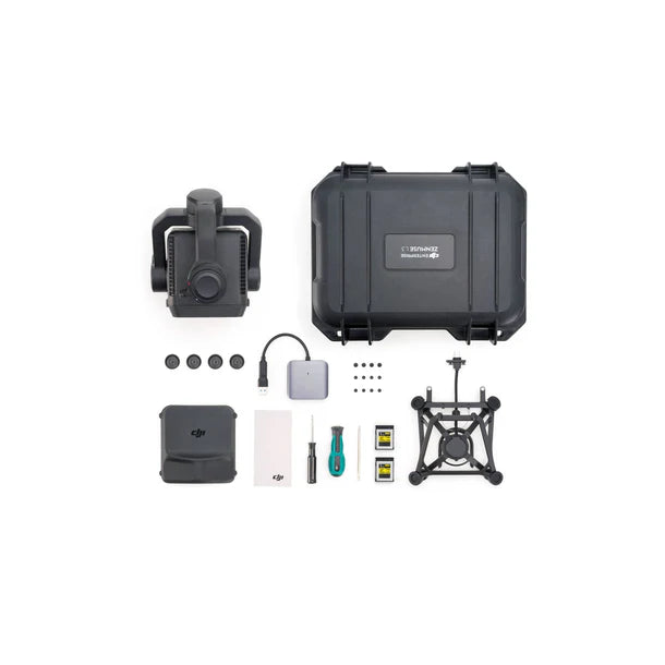
Included Items
- Zenmuse L3 Payload sensor
- Single Gimbal Connector ( for M400 )
- Storage Case
- 4× Gimbal Dampers
- CFexpress Memory Card
- CFexpress Type B Card Reader
- DJI M400 Carrying Case Insert
- Lens Cleaning Cloth
- Screws and Tools
Zenmuse L3 Frequently Asked Questions (FAQ)
How much is the new DJI Zenmuse L3?
As of November 4, 2025, the price for the Zenmuse L3 starts at $20,225 CAD ($14,602.28 USD note this is a FX conversion price) plus applicable taxes and warranty plans. Please contact us for a full quote.
How much is a ready-to-survey LiDAR package?
The DJI Zenmuse L3 LiDAR ($20,225 CAD) with Matrice 400 full base package ($14,099 CAD) is an excellent kit to start drone mapping/surveying. It will cost approximately $34,324 CAD plus applicable taxes and warranty plans. We recommend adding additional TB100 flight batteries for extended surveying missions.
Can the Zenmuse L3 be on the Matrice 300 / 350 platform?
No, it is designed for the Matrice 400 platform only at this time.
What is the maximum range of the Zenmuse L3 LiDAR?
Up to 950 m on 10 % reflectivity targets at 100 kHz and 2000 m on 80 % reflectivity targets under optimal conditions (100 klx ambient light, 23 km visibility).
Which drones support the Zenmuse L3?
The L3 mounts exclusively on the DJI Matrice 400 series using the Zenmuse L3 Single Gimbal Connector.
How accurate is the system for surveying?
Vertical accuracy of 3 cm (120 m) and 5 cm (300 m) RMSE, horizontal accuracy of 4 cm and 7.5 cm respectively, under DJI lab test conditions with RTK and DJI Terra optimization enabled.
What software is required for processing?
DJI Pilot 2 for data capture, DJI Terra for point cloud generation, DJI Modify for editing, and FlightHub 2 for cloud management.
Can it detect power lines or wires?
Yes. The L3 can detect 21.6 mm steel core wires up to 300 m and 18.4 mm PVC wires up to 100 m in full sunlight at 350 kHz.
RMUS Canada is a DJI Gold status trusted partner. Get the best pricing and support on DJI Zenmuse L3 by contacting us today.
Specifications verified against the official manufacturer spec sheet (enterprise.dji.com/zenmuse-l3/specs).
Share


Why RMUS Canada
-
- Gold Tier DJI Enterprise Dealer
- DJI Certified Maintenance and Service Provider
- DJI Dock Certified
- RMUS Hub online training center
-
- Certified Training instructors - former Public Safety RPAS operators
- Emergency Equipment Loaner Program
- Trade in credits available
RMUS Canada Resources
-
Sourcewell
RMUS has an existing contract with Sourcewell, a government agency that helps to make the buying process easier and faster.
-
Sourcewell combines the purchasing power of multiple agencies into one cooperative group that helps to streamline the procurement process for governmental agencies such as Public Safety and Educational agencies.
-
Consult our sales team to learn more about Sourcewell and how to use it to its fullest power.
For more information visit: Sourcewell